


va oise lac vaches et vers glacier

sabine38
User
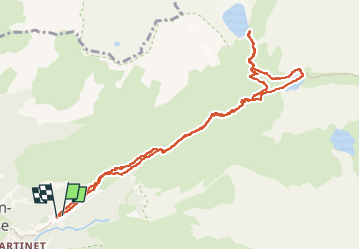

Length
11.8 km

Max alt
2516 m

Uphill gradient
850 m
Km-Effort
23 km

Min alt
1660 m

Downhill gradient
856 m
Boucle
Yes
Creation date :
2024-11-07 08:16:23.616
Updated on :
2024-11-07 15:02:26.029
6h44
Difficulty : Medium

FREE GPS app for hiking
 SityTrail
IGN / Geographical institutes
SityTrail Plus
The world is yours!
About
Trail Walking of 11.8 km to be discovered at Auvergne-Rhône-Alpes, Savoy, Pralognan-la-Vanoise. This trail is proposed by sabine38.
Positioning
Country:
France
Region :
Auvergne-Rhône-Alpes
Department/Province :
Savoy
Municipality :
Pralognan-la-Vanoise
Location:
Unknown
Start:(Dec)
Start:(UTM)
322797 ; 5027879 (32T) N.
Comments