


Méribel - R9 Col du Fruit

Hugues01
User
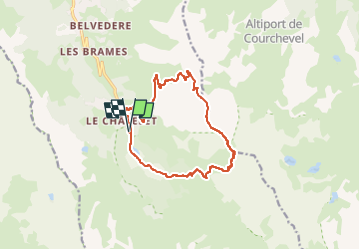

Length
13.6 km

Max alt
2687 m

Uphill gradient
1017 m
Km-Effort
27 km

Min alt
1689 m

Downhill gradient
1017 m
Boucle
Yes
Creation date :
2024-11-10 11:13:21.502
Updated on :
2024-11-10 12:37:53.719
6h09
Difficulty : Very difficult

FREE GPS app for hiking
 SityTrail
IGN / Geographical institutes
SityTrail Plus
The world is yours!
About
Trail Walking of 13.6 km to be discovered at Auvergne-Rhône-Alpes, Savoy, Les Allues. This trail is proposed by Hugues01.
Positioning
Country:
France
Region :
Auvergne-Rhône-Alpes
Department/Province :
Savoy
Municipality :
Les Allues
Location:
Unknown
Start:(Dec)
Start:(UTM)
310868 ; 5026600 (32T) N.
Comments