


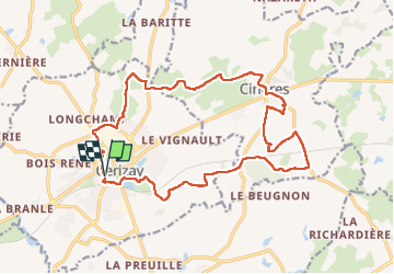
Rando de Cerizay (79)

dudu79
User

Length
19.8 km

Max alt
224 m

Uphill gradient
228 m
Km-Effort
23 km

Min alt
164 m

Downhill gradient
226 m
Boucle
Yes
Creation date :
2024-11-10 07:13:17.903
Updated on :
2024-11-10 11:15:58.557
3h51
Difficulty : Medium

FREE GPS app for hiking
 SityTrail
IGN / Geographical institutes
SityTrail Plus
The world is yours!
About
Trail Walking of 19.8 km to be discovered at New Aquitaine, Deux-Sèvres, Cerizay. This trail is proposed by dudu79.
Positioning
Country:
France
Region :
New Aquitaine
Department/Province :
Deux-Sèvres
Municipality :
Cerizay
Location:
Unknown
Start:(Dec)
Start:(UTM)
677627 ; 5187742 (30T) N.
Comments