


face sur ardin

favraux
User
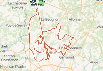

Length
129 km

Max alt
233 m

Uphill gradient
1759 m
Km-Effort
153 km

Min alt
34 m

Downhill gradient
1753 m
Boucle
Yes
Creation date :
2024-11-09 16:27:12.848
Updated on :
2024-11-10 15:13:17.655
3h16
Difficulty : Very easy

FREE GPS app for hiking
 SityTrail
IGN / Geographical institutes
SityTrail Plus
The world is yours!
About
Trail Quad of 129 km to be discovered at New Aquitaine, Deux-Sèvres, Scillé. This trail is proposed by favraux.
Description
téléphone 2024
Positioning
Country:
France
Region :
New Aquitaine
Department/Province :
Deux-Sèvres
Municipality :
Scillé
Location:
Unknown
Start:(Dec)
Start:(UTM)
686845 ; 5165406 (30T) N.
Comments