


Cadiéres de Brandis par la Colle

soca
User
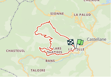

Length
15.8 km

Max alt
1552 m

Uphill gradient
928 m
Km-Effort
28 km

Min alt
759 m

Downhill gradient
918 m
Boucle
Yes
Creation date :
2015-05-25 00:00:00.0
Updated on :
2022-05-21 09:14:04.73
6h05
Difficulty : Medium

FREE GPS app for hiking
 SityTrail
IGN / Geographical institutes
SityTrail Plus
The world is yours!
About
Trail Walking of 15.8 km to be discovered at Provence-Alpes-Côte d'Azur, Alpes-de-Haute-Provence, Castellane. This trail is proposed by soca.
Positioning
Country:
France
Region :
Provence-Alpes-Côte d'Azur
Department/Province :
Alpes-de-Haute-Provence
Municipality :
Castellane
Location:
Unknown
Start:(Dec)
Start:(UTM)
298228 ; 4856952 (32T) N.
Comments