


Dent du Villard

loicthev
User

Length
11.5 km

Max alt
2276 m

Uphill gradient
807 m
Km-Effort
22 km

Min alt
1536 m

Downhill gradient
809 m
Boucle
Yes
Creation date :
2024-11-14 08:46:56.706
Updated on :
2024-11-14 13:22:59.163
2h58
Difficulty : Easy

FREE GPS app for hiking
 SityTrail
IGN / Geographical institutes
SityTrail Plus
The world is yours!
About
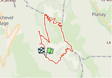
Trail Walking of 11.5 km to be discovered at Auvergne-Rhône-Alpes, Savoy, Courchevel. This trail is proposed by loicthev.
Description
Rando dent du Villard
Lac de la Rosière > col de la chal > dent du villard > lac de la Rosière
14/11/2024
Alexandre
Positioning
Country:
France
Region :
Auvergne-Rhône-Alpes
Department/Province :
Savoy
Municipality :
Courchevel
Location:
Saint-Bon-Tarentaise
Start:(Dec)
Start:(UTM)
317507 ; 5030885 (32T) N.
Comments