


vieux Thann

danif
User
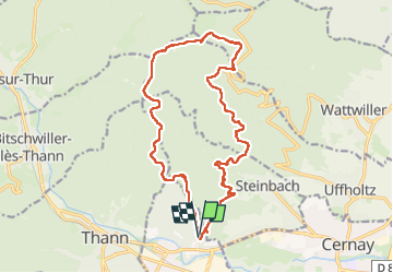

Length
17.7 km

Max alt
1091 m

Uphill gradient
868 m
Km-Effort
29 km

Min alt
360 m

Downhill gradient
869 m
Boucle
Yes
Creation date :
2024-11-14 08:20:32.469
Updated on :
2024-11-14 15:52:11.676
7h30
Difficulty : Very difficult

FREE GPS app for hiking
 SityTrail
IGN / Geographical institutes
SityTrail Plus
The world is yours!
About
Trail Walking of 17.7 km to be discovered at Grand Est, Haut-Rhin, Vieux-Thann. This trail is proposed by danif.
Positioning
Country:
France
Region :
Grand Est
Department/Province :
Haut-Rhin
Municipality :
Vieux-Thann
Location:
Unknown
Start:(Dec)
Start:(UTM)
360122 ; 5296918 (32T) N.
Comments