


Geishouse Sattelfels

Alain28/01
User
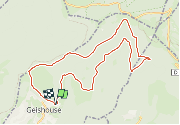

Length
11 km

Max alt
1207 m

Uphill gradient
488 m
Km-Effort
17.5 km

Min alt
761 m

Downhill gradient
488 m
Boucle
Yes
Creation date :
2024-11-16 17:02:14.931
Updated on :
2024-11-16 17:04:29.024
3h58
Difficulty : Difficult

FREE GPS app for hiking
 SityTrail
IGN / Geographical institutes
SityTrail Plus
The world is yours!
About
Trail Walking of 11 km to be discovered at Grand Est, Haut-Rhin, Geishouse. This trail is proposed by Alain28/01.
Positioning
Country:
France
Region :
Grand Est
Department/Province :
Haut-Rhin
Municipality :
Geishouse
Location:
Unknown
Start:(Dec)
Start:(UTM)
355312 ; 5305288 (32T) N.
Comments