


Sentheim Saegenkopf Hutte

Alain28/01
User
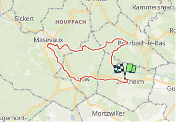

Length
14.5 km

Max alt
534 m

Uphill gradient
278 m
Km-Effort
18.2 km

Min alt
353 m

Downhill gradient
278 m
Boucle
Yes
Creation date :
2024-11-16 17:11:59.0
Updated on :
2024-11-16 17:13:23.741
4h08
Difficulty : Easy

FREE GPS app for hiking
 SityTrail
IGN / Geographical institutes
SityTrail Plus
The world is yours!
About
Trail On foot of 14.5 km to be discovered at Grand Est, Haut-Rhin, Sentheim. This trail is proposed by Alain28/01.
Positioning
Country:
France
Region :
Grand Est
Department/Province :
Haut-Rhin
Municipality :
Sentheim
Location:
Unknown
Start:(Dec)
Start:(UTM)
353796 ; 5291037 (32T) N.
Comments