


123

mitch1952
User
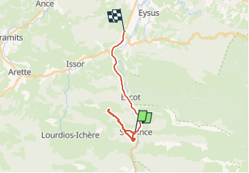

Length
19.5 km

Max alt
879 m

Uphill gradient
706 m
Km-Effort
29 km

Min alt
270 m

Downhill gradient
773 m
Boucle
No
Creation date :
2024-11-15 08:25:17.884
Updated on :
2024-11-21 17:34:21.952
6h05
Difficulty : Very difficult

FREE GPS app for hiking
 SityTrail
IGN / Geographical institutes
SityTrail Plus
The world is yours!
About
Trail Walking of 19.5 km to be discovered at New Aquitaine, Pyrénées-Atlantiques, Sarrance. This trail is proposed by mitch1952.
Positioning
Country:
France
Region :
New Aquitaine
Department/Province :
Pyrénées-Atlantiques
Municipality :
Sarrance
Location:
Unknown
Start:(Dec)
Start:(UTM)
695260 ; 4769291 (30T) N.
Comments