


Bretten Bellemagny Traubach le Bas, le Haut, Sternenberg

Alain28/01
User
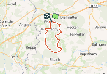

Length
18.2 km

Max alt
385 m

Uphill gradient
309 m
Km-Effort
22 km

Min alt
301 m

Downhill gradient
303 m
Boucle
Yes
Creation date :
2024-11-23 09:30:48.272
Updated on :
2024-11-23 09:33:57.45
5h03
Difficulty : Medium

FREE GPS app for hiking
 SityTrail
IGN / Geographical institutes
SityTrail Plus
The world is yours!
About
Trail Walking of 18.2 km to be discovered at Grand Est, Haut-Rhin, Bretten. This trail is proposed by Alain28/01.
Positioning
Country:
France
Region :
Grand Est
Department/Province :
Haut-Rhin
Municipality :
Bretten
Location:
Unknown
Start:(Dec)
Start:(UTM)
355371 ; 5284616 (32T) N.
Comments