


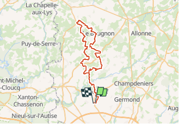
randonnée du telethon

favraux
User

Length
62 km

Max alt
203 m

Uphill gradient
862 m
Km-Effort
73 km

Min alt
50 m

Downhill gradient
861 m
Boucle
No
Creation date :
2024-11-24 09:57:47.097
Updated on :
2024-11-24 15:24:27.224
5h00
Difficulty : Easy

FREE GPS app for hiking
 SityTrail
IGN / Geographical institutes
SityTrail Plus
The world is yours!
About
Trail 4x4 of 62 km to be discovered at New Aquitaine, Deux-Sèvres. This trail is proposed by favraux.
Positioning
Country:
France
Region :
New Aquitaine
Department/Province :
Deux-Sèvres
Municipality :
Unknown
Location:
Unknown
Start:(Dec)
Start:(UTM)
691274 ; 5146983 (30T) N.
Comments