


Boucle St Orse

waggy
User
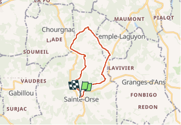

Length
11.2 km

Max alt
272 m

Uphill gradient
208 m
Km-Effort
14 km

Min alt
181 m

Downhill gradient
217 m
Boucle
Yes
Creation date :
2024-11-26 08:02:07.838
Updated on :
2024-11-26 11:01:02.483
2h58
Difficulty : Difficult

FREE GPS app for hiking
 SityTrail
IGN / Geographical institutes
SityTrail Plus
The world is yours!
About
Trail Walking of 11.2 km to be discovered at New Aquitaine, Dordogne, Sainte-Orse. This trail is proposed by waggy.
Positioning
Country:
France
Region :
New Aquitaine
Department/Province :
Dordogne
Municipality :
Sainte-Orse
Location:
Unknown
Start:(Dec)
Start:(UTM)
348796 ; 5007373 (31T) N.
Comments