Mercredi 12/24- Becherkopf- Thann

chantalwaltzer
User
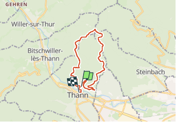

Length
12.5 km

Max alt
873 m

Uphill gradient
569 m
Km-Effort
20 km

Min alt
333 m

Downhill gradient
582 m
Boucle
No
Creation date :
2024-12-04 08:55:24.0
Updated on :
2024-12-04 19:11:29.649
4h46
Difficulty : Very difficult

FREE GPS app for hiking
 SityTrail
IGN / Geographical institutes
SityTrail Plus
The world is yours!
About
Trail Walking of 12.5 km to be discovered at Grand Est, Haut-Rhin, Thann. This trail is proposed by chantalwaltzer.
Description
bien
Positioning
Country:
France
Region :
Grand Est
Department/Province :
Haut-Rhin
Municipality :
Thann
Location:
Unknown
Start:(Dec)
Start:(UTM)
358123 ; 5297374 (32T) N.
Comments