


Le bonhomme col du brezouard

juliengsell
User
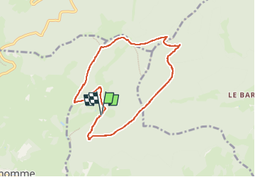

Length
7.6 km

Max alt
1181 m

Uphill gradient
380 m
Km-Effort
12.7 km

Min alt
843 m

Downhill gradient
379 m
Boucle
Yes
Creation date :
2024-11-17 09:42:25.0
Updated on :
2024-12-08 10:27:16.24

FREE GPS app for hiking
 SityTrail
IGN / Geographical institutes
SityTrail Plus
The world is yours!
About
Trail of 7.6 km to be discovered at Grand Est, Haut-Rhin, Lapoutroie. This trail is proposed by juliengsell.
Photos


Positioning
Country:
France
Region :
Grand Est
Department/Province :
Haut-Rhin
Municipality :
Lapoutroie
Location:
Unknown
Start:(Dec)
Start:(UTM)
361638 ; 5338207 (32U) N.
Comments