


SityTrail - Ventoux 2024 46K

kayamb
User
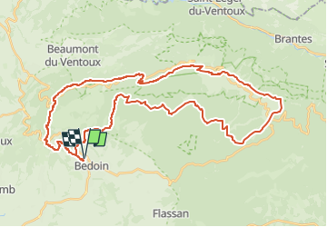

Length
47 km

Max alt
1910 m

Uphill gradient
2321 m
Km-Effort
78 km

Min alt
313 m

Downhill gradient
2321 m
Boucle
Yes
Creation date :
2024-12-09 18:29:17.877
Updated on :
2024-12-09 18:30:03.724
0m
Difficulty : Difficult

FREE GPS app for hiking
 SityTrail
IGN / Geographical institutes
SityTrail Plus
The world is yours!
About
Trail Trail of 47 km to be discovered at Provence-Alpes-Côte d'Azur, Vaucluse, Bédoin. This trail is proposed by kayamb.
Positioning
Country:
France
Region :
Provence-Alpes-Côte d'Azur
Department/Province :
Vaucluse
Municipality :
Bédoin
Location:
Unknown
Start:(Dec)
Start:(UTM)
674073 ; 4888393 (31T) N.
Comments