


Montamisé Ouest

phjb
User
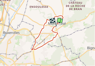

Length
12.1 km

Max alt
123 m

Uphill gradient
134 m
Km-Effort
13.9 km

Min alt
83 m

Downhill gradient
133 m
Boucle
Yes
Creation date :
2024-12-10 07:43:15.154
Updated on :
2024-12-10 10:50:29.432
2h33
Difficulty : Very easy

FREE GPS app for hiking
 SityTrail
IGN / Geographical institutes
SityTrail Plus
The world is yours!
About
Trail Walking of 12.1 km to be discovered at New Aquitaine, Vienne, Montamisé. This trail is proposed by phjb.
Positioning
Country:
France
Region :
New Aquitaine
Department/Province :
Vienne
Municipality :
Montamisé
Location:
Unknown
Start:(Dec)
Start:(UTM)
302531 ; 5165958 (31T) N.
Comments