


Rimbach Zell

Alain28/01
User
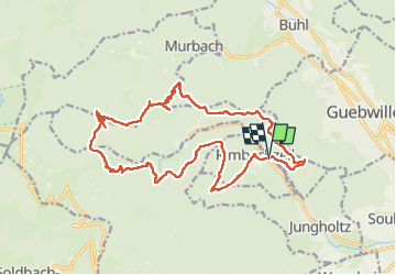

Length
20 km

Max alt
1024 m

Uphill gradient
852 m
Km-Effort
31 km

Min alt
397 m

Downhill gradient
856 m
Boucle
Yes
Creation date :
2024-12-12 08:07:32.62
Updated on :
2024-12-12 14:35:31.21
4h46
Difficulty : Medium

FREE GPS app for hiking
 SityTrail
IGN / Geographical institutes
SityTrail Plus
The world is yours!
About
Trail Walking of 20 km to be discovered at Grand Est, Haut-Rhin, Rimbachzell. This trail is proposed by Alain28/01.
Positioning
Country:
France
Region :
Grand Est
Department/Province :
Haut-Rhin
Municipality :
Rimbachzell
Location:
Unknown
Start:(Dec)
Start:(UTM)
364028 ; 5306746 (32T) N.
Comments