


Bedous Bugala G3

LouisROGER
User GUIDE
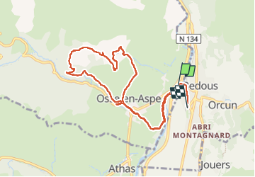

Length
10.6 km

Max alt
780 m

Uphill gradient
389 m
Km-Effort
15.8 km

Min alt
405 m

Downhill gradient
391 m
Boucle
No
Creation date :
2024-12-13 08:58:03.91
Updated on :
2024-12-13 15:06:45.208
5h08
Difficulty : Difficult

FREE GPS app for hiking
 SityTrail
IGN / Geographical institutes
SityTrail Plus
The world is yours!
About
Trail Walking of 10.6 km to be discovered at New Aquitaine, Pyrénées-Atlantiques, Osse-en-Aspe. This trail is proposed by LouisROGER.
Positioning
Country:
France
Region :
New Aquitaine
Department/Province :
Pyrénées-Atlantiques
Municipality :
Osse-en-Aspe
Location:
Unknown
Start:(Dec)
Start:(UTM)
695159 ; 4763503 (30T) N.
Comments