Trail Walking Saulzet-le-Froid - Le Puy Baladou - Photo
 Gegetop
Gegetop

User

© OpenStreetMap contributors
Length
Length
12.5 km
Max alt
Max alt
1427 m
Uphill gradient
Uphill gradient
357 m
Km-Effort
Km-Effort  
17.3 km
Min alt
Min alt
1120 m
Downhill gradient
Downhill gradient
358 m
Boucle
Boucle
Yes
Creation date :
2015-06-05 00:00:00.0
Updated on :
2022-09-12 15:56:38.742

(3 Reviews)

Walking
Walking
2h54
Difficulty : Easy

Scan this QR Code to open this trail in the SityTrail application

FREE GPS app for hiking

Logo SityTrail SityTrail

IGN / Geographical institutes

Download SityTrail from the App Store Download SityTrail from Google Play

Logo SityTrail SityTrail World

The world is yours!

Download SityTrail from the App Store Download SityTrail from Google Play Download SityTrail on Huawei AppGallery

About

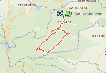
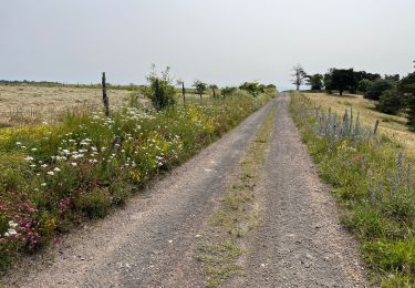
Trail Walking of 12.5 km to be discovered at Auvergne-Rhône-Alpes, Puy-de-Dôme, Saulzet-le-Froid. This trail is proposed by Gegetop.

Description

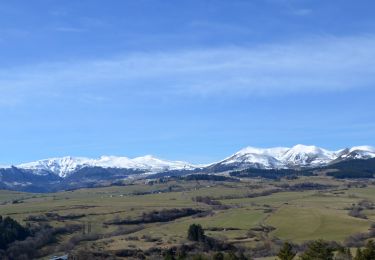
Balade très agréable à faire au printemps parmi les genêts en fleur accompagné des chants d'oiseaux, alouettes, pinsons et bien d'autres.

Elevation profile

Photos

Points of interest

Point of interest Saulzet-le-Froid - Point 2 - Photo
Gegetop
SAULZET-LE-FROID 

Positioning

Country:
France
Region :
Auvergne-Rhône-Alpes
Department/Province :
Puy-de-Dôme
Municipality :
Saulzet-le-Froid
Location:
Unknown
Start:(UTM)
491404 ; 5053620 (31T) N.

Comments

Please log in to post a review or rate the element


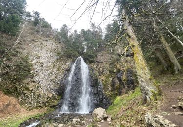
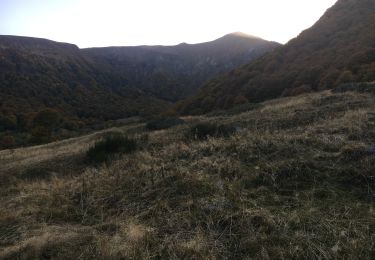
Super jolie vue, balade facile et agreable


Trails nearby

Trail Walking Orcival - Lac de Servières à partir du Café du Lac - Photo
Walking
Dalma Chuck

Walking

Medium
(1)
Orcival, Auvergne-Rhône-Alpes, Puy-de-Dôme, France
6.6 km | 9.5 km-effort
2h 9min
Yes
Trail Walking Le Vernet-Sainte-Marguerite - Vernet_Puy_Alou - Photo
Walking
GUIDE
jagarnier

Walking

Medium
(1)
Le Vernet-Sainte-Marguerite, Auvergne-Rhône-Alpes, Puy-de-Dôme, France
9.9 km | 13.1 km-effort
2h 50min
Yes
Trail On foot Mont-Dore - Les Cascades - Photo
On foot
PRO

On foot

Medium
Mont-Dore, Auvergne-Rhône-Alpes, Puy-de-Dôme, France
15.7 km | 27 km-effort
6h 8min
Yes
Trail Walking Chambon-sur-Lac - Boucle du col de la croix Morand - Photo
Walking
zefreefly

Walking

Easy
Chambon-sur-Lac, Auvergne-Rhône-Alpes, Puy-de-Dôme, France
22 km | 35 km-effort
6h 24min
Yes
Trail Walking Orcival - Serviere_Aiguiller_T - Photo
Walking
force

Walking

Difficult
Orcival, Auvergne-Rhône-Alpes, Puy-de-Dôme, France
12.2 km | 17.2 km-effort
2h 46min
Yes
Trail Walking Le Vernet-Sainte-Marguerite - Autour du Puy d’Alou - Photo
Walking
Dalma Chuck

Walking

Medium
Le Vernet-Sainte-Marguerite, Auvergne-Rhône-Alpes, Puy-de-Dôme, France
5.6 km | 7 km-effort
1h 11min
Yes
Trail Walking Le Vernet-Sainte-Marguerite - Le Puy d’Alou - Photo
Walking
Dalma Chuck

Walking

Medium
Le Vernet-Sainte-Marguerite, Auvergne-Rhône-Alpes, Puy-de-Dôme, France
6.1 km | 8 km-effort
1h 15min
Yes
Trail Walking Murol - Beaune_Monne_Fredet - Photo
Walking
GUIDE
jagarnier

Walking

Medium
Murol, Auvergne-Rhône-Alpes, Puy-de-Dôme, France
12.5 km | 17.4 km-effort
3h 45min
Yes
Trail Walking Chambon-sur-Lac - Crêtes sancy cols - Photo
Walking
vincentdr

Walking

Very difficult
Chambon-sur-Lac, Auvergne-Rhône-Alpes, Puy-de-Dôme, France
15.6 km | 27 km-effort
5h 10min
No


Close
My subscriptions