Trail Walking Saint-Maurice - Via Francigena - Photo
 verbier
verbier

User

© OpenStreetMap contributors
Length
Length
95 km
Max alt
Max alt
2478 m
Uphill gradient
Uphill gradient
4743 m
Km-Effort
Km-Effort  
158 km
Min alt
Min alt
413 m
Downhill gradient
Downhill gradient
4585 m
Boucle
Boucle
No
Creation date :
2014-12-10 00:00:00.0
Updated on :
2014-12-10 00:00:00.0

(0 Reviews)

Walking
Walking
27h24
Difficulty : Unknown

Scan this QR Code to open this trail in the SityTrail application

FREE GPS app for hiking

Logo SityTrail SityTrail

IGN / Geographical institutes

Download SityTrail from the App Store Download SityTrail from Google Play

Logo SityTrail SityTrail World

The world is yours!

Download SityTrail from the App Store Download SityTrail from Google Play Download SityTrail on Huawei AppGallery

About

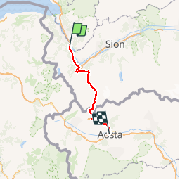
Trail Walking of 95 km to be discovered at Valais/Wallis, Saint-Maurice, Saint-Maurice. This trail is proposed by verbier.

Description

L''itinéraire proposé vous emmène, en sept jours, de St-Maurice d''Agaune à Aosta par le col du Grand St-Bernard, certainement l''étape la plus symbolique de toute la ViaFrancigena.

Ce forfait est réservable intégralement auprès de l''Office du Tourisme d''Orsières :  41 27 783 32 48 ou reservation@v-sb.ch

Plus d''informations sur : www.viafrancigena.ch

Étape 1: St-Maurice–Vernayaz–Martigny
La marche s’effectue sur l’ancien «chemin royal» en longeant le versant, le chemin traverse Evionnaz et Vernayaz. Temps de marche: 4h15, distance : 17 km, Repas et nuitée à Martigny

Étape 2: Martigny–Sembrancher–Orsières
La ViaFrancigena s’élève en rive droite de la Dranse, on atteint Bovernier, puis Orsières par le «chemin Napoléon». Temps de marche: 6h15, distance: 19 km, Repas et nuitée à Orsières

Étape 3: Orsières–Liddes–Bourg-St-Pierre
L’itinéraire suit la Dranse, rejoint Liddes pour suivre le chemin historique jusqu’à Bourg-Saint-Pierre. Temps de marche: 4h45, distance : 13 km, Repas et nuitée à Bourg-Saint-Pierre

Étape 4: Bourg-St-Pierre–Grand-St-Bernard
Cette étape est une des plus symboliques, on accède à l’hospice, point culminant de la ViaFrancigena entre Canterbury et Rome. Temps de marche: 5h00, distance : 13 km, Repas et nuitée au Grand-Saint-Bernard

Étape 5: Grd-St-Bernard–St-Oyen/Etroubles
Sur le versant italien la ViaFrancigena rejoint St-Rhémy (I) puis franchit la route internationale et longe la vallée jusqu’à St-Oyen (I). Temps de marche: 4h, distance : 12 km, Repas et nuitée à St-Oyen/Etroubles

Étape 6 : St-Oyen/Etroubles–Gignod–Aosta
La ViaFrancigena suit la rive droite de la vallée jusqu’à Gignod (I) puis plonge sur l’ancienne cité romaine Augusta Praetoria. Temps de marche: 3h45, distance : 16 km, Repas et nuitée à Aosta

Elevation profile

Points of interest

Point of interest Orsières - Orsières - Photo
verbier
ORSIÈRES 
Point of interest Saint-Maurice - St-Maurice - Photo
verbier
SAINT-MAURICE 
Point of interest Martigny - Martigny - Photo
verbier
MARTIGNY 
Point of interest Sembrancher - Chemin de Napoléon - Photo
verbier
SEMBRANCHER 
Point of interest Bourg-Saint-Pierre - Bourg-St-Pierre - Photo
verbier
BOURG-SAINT-PIERRE 
Point of interest Bourg-Saint-Pierre - Hospice du Grand St-Bernard - Photo
verbier
BOURG-SAINT-PIERRE 
Point of interest Saint-Oyen - St-Oyen - Photo
verbier
SAINT-OYEN 
Point of interest Etroubles - Etroubles - Photo
verbier
ETROUBLES 
Point of interest Aosta - Aosta - Photo
verbier
AOSTA 

Positioning

Country:
Switzerland
Region :
Valais/Wallis
Department/Province :
Saint-Maurice
Municipality :
Saint-Maurice
Location:
Saint-Maurice
Start:(UTM)
346027 ; 5120395 (32T) N.

Trails nearby

Trail On foot Evionnaz - Chemin pédestre, région Martigny - Photo
On foot
PRO

On foot

Easy
Evionnaz, Valais/Wallis, Saint-Maurice, Switzerland
14.3 km | 17.1 km-effort
3h 52min
No
Trail On foot Saint-Maurice - Tour des Dents du Midi - Photo
On foot
PRO

On foot

Very difficult
Saint-Maurice, Valais/Wallis, Saint-Maurice, Switzerland
46 km | 88 km-effort
19h 58min
Yes
Trail Walking Saint-Maurice - Tour des dents du midi - Photo
Walking
GhiJoe

Walking

Medium
Saint-Maurice, Valais/Wallis, Saint-Maurice, Switzerland
59 km | 107 km-effort
23h 39min
Yes
Trail Mountain bike Saint-Maurice - Bike32922 - Photo
Mountain bike
GUIDE+

Mountain bike

Very easy
Saint-Maurice, Valais/Wallis, Saint-Maurice, Switzerland
26 km | 41 km-effort
Unknown
Yes
Trail Walking Saint-Maurice - Abenteuer-Trek in ein unbekanntes Wallis. Mex - Salanfe (Hotel) - Photo
Walking
GUIDE+

Walking

Very easy
Saint-Maurice, Valais/Wallis, Saint-Maurice, Switzerland
9.4 km | 23 km-effort
Unknown
No
Trail Walking Vérossaz - huetten_03 - Photo
Walking
GUIDE+

Walking

Very easy
Vérossaz, Valais/Wallis, Saint-Maurice, Switzerland
46 km | 87 km-effort
14h 46min
Yes
Trail Walking Lavey-Morcles - Circuit Lavey-Les-Bains 05.2016 - Photo
Walking
duamerg

Walking

Medium
Lavey-Morcles, Vaud, District d'Aigle, Switzerland
10.6 km | 13.1 km-effort
3h 6min
Yes
Trail Walking Lavey-Morcles - Morcles, La Tourche, Rionda - Photo
Walking
jipi2

Walking

Medium
Lavey-Morcles, Vaud, District d'Aigle, Switzerland
11.2 km | 25 km-effort
5h 3min
Yes
Trail Walking Bex - Bex - Frenières - Les Verneys - Bex 04.05.14 - Photo
Walking
duamerg

Walking

Medium
Bex, Vaud, District d'Aigle, Switzerland
13.5 km | 23 km-effort
4h 30min
Yes


Close
My subscriptions