


phare de chassirons

Didier-114
User
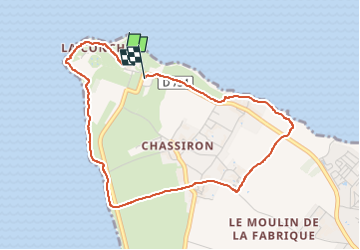

Length
4.3 km

Max alt
11 m

Uphill gradient
20 m
Km-Effort
4.6 km

Min alt
0 m

Downhill gradient
19 m
Boucle
Yes
Creation date :
2024-12-26 14:31:48.472
Updated on :
2024-12-26 15:50:37.491
1h17
Difficulty : Easy

FREE GPS app for hiking
 SityTrail
IGN / Geographical institutes
SityTrail Plus
The world is yours!
About
Trail Walking of 4.3 km to be discovered at New Aquitaine, Charente-Maritime, Saint-Denis-d'Oléron. This trail is proposed by Didier-114.
Description
monté au phare avant
Positioning
Country:
France
Region :
New Aquitaine
Department/Province :
Charente-Maritime
Municipality :
Saint-Denis-d'Oléron
Location:
Unknown
Start:(Dec)
Start:(UTM)
623184 ; 5100440 (30T) N.
Comments