


Montagne du Rey

chasle
User
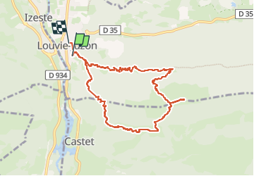

Length
10.5 km

Max alt
1339 m

Uphill gradient
926 m
Km-Effort
23 km

Min alt
421 m

Downhill gradient
926 m
Boucle
No
Creation date :
2024-12-27 07:16:55.477
Updated on :
2024-12-27 13:55:31.907
3h12
Difficulty : Difficult

FREE GPS app for hiking
 SityTrail
IGN / Geographical institutes
SityTrail Plus
The world is yours!
About
Trail Walking of 10.5 km to be discovered at New Aquitaine, Pyrénées-Atlantiques, Louvie-Juzon. This trail is proposed by chasle.
Positioning
Country:
France
Region :
New Aquitaine
Department/Province :
Pyrénées-Atlantiques
Municipality :
Louvie-Juzon
Location:
Unknown
Start:(Dec)
Start:(UTM)
710172 ; 4773440 (30T) N.
Comments