


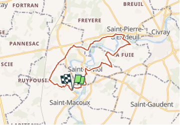
VAL DE COMPORTE 2 LES 3 SAINTS

Rembliere
User

Length
14.5 km

Max alt
139 m

Uphill gradient
162 m
Km-Effort
16.6 km

Min alt
100 m

Downhill gradient
162 m
Boucle
Yes
Creation date :
2025-01-01 16:37:47.283
Updated on :
2025-01-01 16:38:16.816
3h46
Difficulty : Difficult

FREE GPS app for hiking
 SityTrail
IGN / Geographical institutes
SityTrail Plus
The world is yours!
About
Trail Walking of 14.5 km to be discovered at New Aquitaine, Vienne, Saint-Macoux. This trail is proposed by Rembliere.
Positioning
Country:
France
Region :
New Aquitaine
Department/Province :
Vienne
Municipality :
Saint-Macoux
Location:
Unknown
Start:(Dec)
Start:(UTM)
286350 ; 5111397 (31T) N.
Comments