


ste Victoire pic des mouches

taguette
User
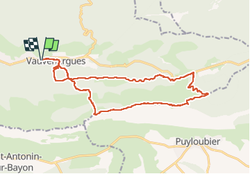

Length
19.9 km

Max alt
998 m

Uphill gradient
847 m
Km-Effort
31 km

Min alt
396 m

Downhill gradient
847 m
Boucle
Yes
Creation date :
2025-01-07 07:28:46.557
Updated on :
2025-01-07 15:02:56.093
7h33
Difficulty : Very difficult

FREE GPS app for hiking
 SityTrail
IGN / Geographical institutes
SityTrail Plus
The world is yours!
About
Trail Walking of 19.9 km to be discovered at Provence-Alpes-Côte d'Azur, Bouches-du-Rhône, Vauvenargues. This trail is proposed by taguette.
Positioning
Country:
France
Region :
Provence-Alpes-Côte d'Azur
Department/Province :
Bouches-du-Rhône
Municipality :
Vauvenargues
Location:
Unknown
Start:(Dec)
Start:(UTM)
709807 ; 4825719 (31T) N.
Comments