


1ere ventoux

mthomas30
User
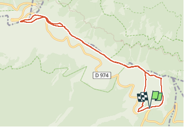

Length
11.2 km

Max alt
1910 m

Uphill gradient
526 m
Km-Effort
18.2 km

Min alt
1423 m

Downhill gradient
525 m
Boucle
Yes
Creation date :
2025-01-08 09:47:00.437
Updated on :
2025-01-08 13:12:50.49
2h34
Difficulty : Medium

FREE GPS app for hiking
 SityTrail
IGN / Geographical institutes
SityTrail Plus
The world is yours!
About
Trail Walking of 11.2 km to be discovered at Provence-Alpes-Côte d'Azur, Vaucluse, Bédoin. This trail is proposed by mthomas30.
Positioning
Country:
France
Region :
Provence-Alpes-Côte d'Azur
Department/Province :
Vaucluse
Municipality :
Bédoin
Location:
Unknown
Start:(Dec)
Start:(UTM)
685447 ; 4891407 (31T) N.
Comments