


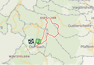
TL 01/2025 Parking cimetière d'Osenbach - Kreutzlein - Hohberg - Heiliger Baum - Chemin St Georges - Osenbuhr - - Pfaffenheimer Trank et retour

patrickbeyrath
User

Length
9.6 km

Max alt
585 m

Uphill gradient
271 m
Km-Effort
13.2 km

Min alt
381 m

Downhill gradient
271 m
Boucle
Yes
Creation date :
2025-01-11 07:13:10.181
Updated on :
2025-01-11 08:10:03.574
3h00
Difficulty : Medium

FREE GPS app for hiking
 SityTrail
IGN / Geographical institutes
SityTrail Plus
The world is yours!
About
Trail Walking of 9.6 km to be discovered at Grand Est, Haut-Rhin, Osenbach. This trail is proposed by patrickbeyrath.
Positioning
Country:
France
Region :
Grand Est
Department/Province :
Haut-Rhin
Municipality :
Osenbach
Location:
Unknown
Start:(Dec)
Start:(UTM)
366935 ; 5316195 (32T) N.
Comments