


Col du Télégraphe - les Verneys

laurentnecca
User
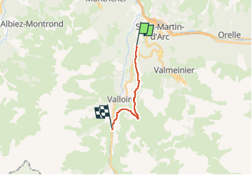

Length
10.6 km

Max alt
1763 m

Uphill gradient
335 m
Km-Effort
15 km

Min alt
1558 m

Downhill gradient
339 m
Boucle
No
Creation date :
2025-01-11 08:37:17.109
Updated on :
2025-01-11 13:25:24.876
3h26
Difficulty : Easy

FREE GPS app for hiking
 SityTrail
IGN / Geographical institutes
SityTrail Plus
The world is yours!
About
Trail Snowshoes of 10.6 km to be discovered at Auvergne-Rhône-Alpes, Savoy, Valloire. This trail is proposed by laurentnecca.
Positioning
Country:
France
Region :
Auvergne-Rhône-Alpes
Department/Province :
Savoy
Municipality :
Valloire
Location:
Unknown
Start:(Dec)
Start:(UTM)
299275 ; 5008652 (32T) N.
Comments