


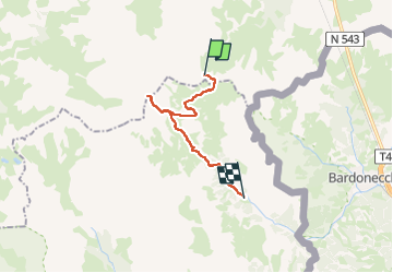
du refuge du mont thabor et retour aux granges de la vallée etroite

Danielle07
User

Length
16.5 km

Max alt
3168 m

Uphill gradient
809 m
Km-Effort
30 km

Min alt
1754 m

Downhill gradient
1542 m
Boucle
No
Creation date :
2025-01-11 17:11:41.042
Updated on :
2025-06-24 17:32:08.576
6h45
Difficulty : Very difficult

FREE GPS app for hiking
 SityTrail
IGN / Geographical institutes
SityTrail Plus
The world is yours!
About
Trail Walking of 16.5 km to be discovered at Auvergne-Rhône-Alpes, Savoy, Modane. This trail is proposed by Danielle07.
Positioning
Country:
France
Region :
Auvergne-Rhône-Alpes
Department/Province :
Savoy
Municipality :
Modane
Location:
Unknown
Start:(Dec)
Start:(UTM)
311250 ; 4999479 (32T) N.
Comments