


Motte castrale-17/01/2025-1/2J-G2

lmc
User
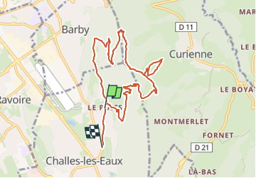

Length
9.4 km

Max alt
799 m

Uphill gradient
454 m
Km-Effort
15.7 km

Min alt
298 m

Downhill gradient
509 m
Boucle
No
Creation date :
2025-01-13 15:12:20.079
Updated on :
2025-01-13 15:13:22.151
3h33
Difficulty : Easy

FREE GPS app for hiking
 SityTrail
IGN / Geographical institutes
SityTrail Plus
The world is yours!
About
Trail Walking of 9.4 km to be discovered at Auvergne-Rhône-Alpes, Savoy, Challes-les-Eaux. This trail is proposed by lmc.
Positioning
Country:
France
Region :
Auvergne-Rhône-Alpes
Department/Province :
Savoy
Municipality :
Challes-les-Eaux
Location:
Unknown
Start:(Dec)
Start:(UTM)
733228 ; 5049200 (31T) N.
Comments