


rando castillon gare

Gbreuilh
User
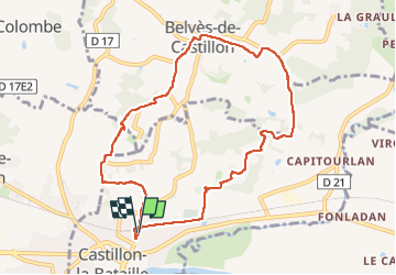

Length
9.2 km

Max alt
104 m

Uphill gradient
232 m
Km-Effort
12.3 km

Min alt
23 m

Downhill gradient
231 m
Boucle
Yes
Creation date :
2025-01-15 08:33:07.866
Updated on :
2025-01-15 10:59:41.977
2h26
Difficulty : Difficult

FREE GPS app for hiking
 SityTrail
IGN / Geographical institutes
SityTrail Plus
The world is yours!
About
Trail Walking of 9.2 km to be discovered at New Aquitaine, Gironde, Castillon-la-Bataille. This trail is proposed by Gbreuilh.
Positioning
Country:
France
Region :
New Aquitaine
Department/Province :
Gironde
Municipality :
Castillon-la-Bataille
Location:
Unknown
Start:(Dec)
Start:(UTM)
733813 ; 4971316 (30T) N.
Comments