


Rando "Marcheurs "..16 / 01 / 2025 .

boubou68
User
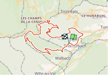

Length
22 km

Max alt
902 m

Uphill gradient
840 m
Km-Effort
33 km

Min alt
288 m

Downhill gradient
833 m
Boucle
Yes
Creation date :
2025-01-16 08:21:50.873
Updated on :
2025-01-16 21:03:17.724
5h39
Difficulty : Very difficult

FREE GPS app for hiking
 SityTrail
IGN / Geographical institutes
SityTrail Plus
The world is yours!
About
Trail Walking of 22 km to be discovered at Grand Est, Haut-Rhin, Zimmerbach. This trail is proposed by boubou68.
Description
Départ Zimmerbach..
Bravo et merci à Alain..Belle rando des Trois Mousquetaires et notre FALBALA..
A si bientôt pour nos copains.
Photos
"
data-pinterest-text="Pin it"
data-tweet-text="share on twitter"
data-facebook-share-url="https://www.sitytrail.com/en/trails/4321420-zimmerbach--rando-xmarcheurs-xxx16-x-01-x-2025-x/?photo=0#lg=1&slide=0"
data-twitter-share-url="https://www.sitytrail.com/en/trails/4321420-zimmerbach--rando-xmarcheurs-xxx16-x-01-x-2025-x/?photo=0#lg=1&slide=0"
data-googleplus-share-url="https://www.sitytrail.com/en/trails/4321420-zimmerbach--rando-xmarcheurs-xxx16-x-01-x-2025-x/?photo=0#lg=1&slide=0"
data-pinterest-share-url="https://www.sitytrail.com/en/trails/4321420-zimmerbach--rando-xmarcheurs-xxx16-x-01-x-2025-x/?photo=0#lg=1&slide=0">
 "
data-pinterest-text="Pin it"
data-tweet-text="share on twitter"
data-facebook-share-url="https://www.sitytrail.com/en/trails/4321420-zimmerbach--rando-xmarcheurs-xxx16-x-01-x-2025-x/?photo=1#lg=1&slide=1"
data-twitter-share-url="https://www.sitytrail.com/en/trails/4321420-zimmerbach--rando-xmarcheurs-xxx16-x-01-x-2025-x/?photo=1#lg=1&slide=1"
data-googleplus-share-url="https://www.sitytrail.com/en/trails/4321420-zimmerbach--rando-xmarcheurs-xxx16-x-01-x-2025-x/?photo=1#lg=1&slide=1"
data-pinterest-share-url="https://www.sitytrail.com/en/trails/4321420-zimmerbach--rando-xmarcheurs-xxx16-x-01-x-2025-x/?photo=1#lg=1&slide=1">
"
data-pinterest-text="Pin it"
data-tweet-text="share on twitter"
data-facebook-share-url="https://www.sitytrail.com/en/trails/4321420-zimmerbach--rando-xmarcheurs-xxx16-x-01-x-2025-x/?photo=1#lg=1&slide=1"
data-twitter-share-url="https://www.sitytrail.com/en/trails/4321420-zimmerbach--rando-xmarcheurs-xxx16-x-01-x-2025-x/?photo=1#lg=1&slide=1"
data-googleplus-share-url="https://www.sitytrail.com/en/trails/4321420-zimmerbach--rando-xmarcheurs-xxx16-x-01-x-2025-x/?photo=1#lg=1&slide=1"
data-pinterest-share-url="https://www.sitytrail.com/en/trails/4321420-zimmerbach--rando-xmarcheurs-xxx16-x-01-x-2025-x/?photo=1#lg=1&slide=1">
 "
data-pinterest-text="Pin it"
data-tweet-text="share on twitter"
data-facebook-share-url="https://www.sitytrail.com/en/trails/4321420-zimmerbach--rando-xmarcheurs-xxx16-x-01-x-2025-x/?photo=2#lg=1&slide=2"
data-twitter-share-url="https://www.sitytrail.com/en/trails/4321420-zimmerbach--rando-xmarcheurs-xxx16-x-01-x-2025-x/?photo=2#lg=1&slide=2"
data-googleplus-share-url="https://www.sitytrail.com/en/trails/4321420-zimmerbach--rando-xmarcheurs-xxx16-x-01-x-2025-x/?photo=2#lg=1&slide=2"
data-pinterest-share-url="https://www.sitytrail.com/en/trails/4321420-zimmerbach--rando-xmarcheurs-xxx16-x-01-x-2025-x/?photo=2#lg=1&slide=2">
"
data-pinterest-text="Pin it"
data-tweet-text="share on twitter"
data-facebook-share-url="https://www.sitytrail.com/en/trails/4321420-zimmerbach--rando-xmarcheurs-xxx16-x-01-x-2025-x/?photo=2#lg=1&slide=2"
data-twitter-share-url="https://www.sitytrail.com/en/trails/4321420-zimmerbach--rando-xmarcheurs-xxx16-x-01-x-2025-x/?photo=2#lg=1&slide=2"
data-googleplus-share-url="https://www.sitytrail.com/en/trails/4321420-zimmerbach--rando-xmarcheurs-xxx16-x-01-x-2025-x/?photo=2#lg=1&slide=2"
data-pinterest-share-url="https://www.sitytrail.com/en/trails/4321420-zimmerbach--rando-xmarcheurs-xxx16-x-01-x-2025-x/?photo=2#lg=1&slide=2">
 "
data-pinterest-text="Pin it"
data-tweet-text="share on twitter"
data-facebook-share-url="https://www.sitytrail.com/en/trails/4321420-zimmerbach--rando-xmarcheurs-xxx16-x-01-x-2025-x/?photo=3#lg=1&slide=3"
data-twitter-share-url="https://www.sitytrail.com/en/trails/4321420-zimmerbach--rando-xmarcheurs-xxx16-x-01-x-2025-x/?photo=3#lg=1&slide=3"
data-googleplus-share-url="https://www.sitytrail.com/en/trails/4321420-zimmerbach--rando-xmarcheurs-xxx16-x-01-x-2025-x/?photo=3#lg=1&slide=3"
data-pinterest-share-url="https://www.sitytrail.com/en/trails/4321420-zimmerbach--rando-xmarcheurs-xxx16-x-01-x-2025-x/?photo=3#lg=1&slide=3">
"
data-pinterest-text="Pin it"
data-tweet-text="share on twitter"
data-facebook-share-url="https://www.sitytrail.com/en/trails/4321420-zimmerbach--rando-xmarcheurs-xxx16-x-01-x-2025-x/?photo=3#lg=1&slide=3"
data-twitter-share-url="https://www.sitytrail.com/en/trails/4321420-zimmerbach--rando-xmarcheurs-xxx16-x-01-x-2025-x/?photo=3#lg=1&slide=3"
data-googleplus-share-url="https://www.sitytrail.com/en/trails/4321420-zimmerbach--rando-xmarcheurs-xxx16-x-01-x-2025-x/?photo=3#lg=1&slide=3"
data-pinterest-share-url="https://www.sitytrail.com/en/trails/4321420-zimmerbach--rando-xmarcheurs-xxx16-x-01-x-2025-x/?photo=3#lg=1&slide=3">
 "
data-pinterest-text="Pin it"
data-tweet-text="share on twitter"
data-facebook-share-url="https://www.sitytrail.com/en/trails/4321420-zimmerbach--rando-xmarcheurs-xxx16-x-01-x-2025-x/?photo=4#lg=1&slide=4"
data-twitter-share-url="https://www.sitytrail.com/en/trails/4321420-zimmerbach--rando-xmarcheurs-xxx16-x-01-x-2025-x/?photo=4#lg=1&slide=4"
data-googleplus-share-url="https://www.sitytrail.com/en/trails/4321420-zimmerbach--rando-xmarcheurs-xxx16-x-01-x-2025-x/?photo=4#lg=1&slide=4"
data-pinterest-share-url="https://www.sitytrail.com/en/trails/4321420-zimmerbach--rando-xmarcheurs-xxx16-x-01-x-2025-x/?photo=4#lg=1&slide=4">
"
data-pinterest-text="Pin it"
data-tweet-text="share on twitter"
data-facebook-share-url="https://www.sitytrail.com/en/trails/4321420-zimmerbach--rando-xmarcheurs-xxx16-x-01-x-2025-x/?photo=4#lg=1&slide=4"
data-twitter-share-url="https://www.sitytrail.com/en/trails/4321420-zimmerbach--rando-xmarcheurs-xxx16-x-01-x-2025-x/?photo=4#lg=1&slide=4"
data-googleplus-share-url="https://www.sitytrail.com/en/trails/4321420-zimmerbach--rando-xmarcheurs-xxx16-x-01-x-2025-x/?photo=4#lg=1&slide=4"
data-pinterest-share-url="https://www.sitytrail.com/en/trails/4321420-zimmerbach--rando-xmarcheurs-xxx16-x-01-x-2025-x/?photo=4#lg=1&slide=4">
 "
data-pinterest-text="Pin it"
data-tweet-text="share on twitter"
data-facebook-share-url="https://www.sitytrail.com/en/trails/4321420-zimmerbach--rando-xmarcheurs-xxx16-x-01-x-2025-x/?photo=5#lg=1&slide=5"
data-twitter-share-url="https://www.sitytrail.com/en/trails/4321420-zimmerbach--rando-xmarcheurs-xxx16-x-01-x-2025-x/?photo=5#lg=1&slide=5"
data-googleplus-share-url="https://www.sitytrail.com/en/trails/4321420-zimmerbach--rando-xmarcheurs-xxx16-x-01-x-2025-x/?photo=5#lg=1&slide=5"
data-pinterest-share-url="https://www.sitytrail.com/en/trails/4321420-zimmerbach--rando-xmarcheurs-xxx16-x-01-x-2025-x/?photo=5#lg=1&slide=5">
"
data-pinterest-text="Pin it"
data-tweet-text="share on twitter"
data-facebook-share-url="https://www.sitytrail.com/en/trails/4321420-zimmerbach--rando-xmarcheurs-xxx16-x-01-x-2025-x/?photo=5#lg=1&slide=5"
data-twitter-share-url="https://www.sitytrail.com/en/trails/4321420-zimmerbach--rando-xmarcheurs-xxx16-x-01-x-2025-x/?photo=5#lg=1&slide=5"
data-googleplus-share-url="https://www.sitytrail.com/en/trails/4321420-zimmerbach--rando-xmarcheurs-xxx16-x-01-x-2025-x/?photo=5#lg=1&slide=5"
data-pinterest-share-url="https://www.sitytrail.com/en/trails/4321420-zimmerbach--rando-xmarcheurs-xxx16-x-01-x-2025-x/?photo=5#lg=1&slide=5">
 "
data-pinterest-text="Pin it"
data-tweet-text="share on twitter"
data-facebook-share-url="https://www.sitytrail.com/en/trails/4321420-zimmerbach--rando-xmarcheurs-xxx16-x-01-x-2025-x/?photo=6#lg=1&slide=6"
data-twitter-share-url="https://www.sitytrail.com/en/trails/4321420-zimmerbach--rando-xmarcheurs-xxx16-x-01-x-2025-x/?photo=6#lg=1&slide=6"
data-googleplus-share-url="https://www.sitytrail.com/en/trails/4321420-zimmerbach--rando-xmarcheurs-xxx16-x-01-x-2025-x/?photo=6#lg=1&slide=6"
data-pinterest-share-url="https://www.sitytrail.com/en/trails/4321420-zimmerbach--rando-xmarcheurs-xxx16-x-01-x-2025-x/?photo=6#lg=1&slide=6">
"
data-pinterest-text="Pin it"
data-tweet-text="share on twitter"
data-facebook-share-url="https://www.sitytrail.com/en/trails/4321420-zimmerbach--rando-xmarcheurs-xxx16-x-01-x-2025-x/?photo=6#lg=1&slide=6"
data-twitter-share-url="https://www.sitytrail.com/en/trails/4321420-zimmerbach--rando-xmarcheurs-xxx16-x-01-x-2025-x/?photo=6#lg=1&slide=6"
data-googleplus-share-url="https://www.sitytrail.com/en/trails/4321420-zimmerbach--rando-xmarcheurs-xxx16-x-01-x-2025-x/?photo=6#lg=1&slide=6"
data-pinterest-share-url="https://www.sitytrail.com/en/trails/4321420-zimmerbach--rando-xmarcheurs-xxx16-x-01-x-2025-x/?photo=6#lg=1&slide=6">
 "
data-pinterest-text="Pin it"
data-tweet-text="share on twitter"
data-facebook-share-url="https://www.sitytrail.com/en/trails/4321420-zimmerbach--rando-xmarcheurs-xxx16-x-01-x-2025-x/?photo=7#lg=1&slide=7"
data-twitter-share-url="https://www.sitytrail.com/en/trails/4321420-zimmerbach--rando-xmarcheurs-xxx16-x-01-x-2025-x/?photo=7#lg=1&slide=7"
data-googleplus-share-url="https://www.sitytrail.com/en/trails/4321420-zimmerbach--rando-xmarcheurs-xxx16-x-01-x-2025-x/?photo=7#lg=1&slide=7"
data-pinterest-share-url="https://www.sitytrail.com/en/trails/4321420-zimmerbach--rando-xmarcheurs-xxx16-x-01-x-2025-x/?photo=7#lg=1&slide=7">
"
data-pinterest-text="Pin it"
data-tweet-text="share on twitter"
data-facebook-share-url="https://www.sitytrail.com/en/trails/4321420-zimmerbach--rando-xmarcheurs-xxx16-x-01-x-2025-x/?photo=7#lg=1&slide=7"
data-twitter-share-url="https://www.sitytrail.com/en/trails/4321420-zimmerbach--rando-xmarcheurs-xxx16-x-01-x-2025-x/?photo=7#lg=1&slide=7"
data-googleplus-share-url="https://www.sitytrail.com/en/trails/4321420-zimmerbach--rando-xmarcheurs-xxx16-x-01-x-2025-x/?photo=7#lg=1&slide=7"
data-pinterest-share-url="https://www.sitytrail.com/en/trails/4321420-zimmerbach--rando-xmarcheurs-xxx16-x-01-x-2025-x/?photo=7#lg=1&slide=7">
 "
data-pinterest-text="Pin it"
data-tweet-text="share on twitter"
data-facebook-share-url="https://www.sitytrail.com/en/trails/4321420-zimmerbach--rando-xmarcheurs-xxx16-x-01-x-2025-x/?photo=8#lg=1&slide=8"
data-twitter-share-url="https://www.sitytrail.com/en/trails/4321420-zimmerbach--rando-xmarcheurs-xxx16-x-01-x-2025-x/?photo=8#lg=1&slide=8"
data-googleplus-share-url="https://www.sitytrail.com/en/trails/4321420-zimmerbach--rando-xmarcheurs-xxx16-x-01-x-2025-x/?photo=8#lg=1&slide=8"
data-pinterest-share-url="https://www.sitytrail.com/en/trails/4321420-zimmerbach--rando-xmarcheurs-xxx16-x-01-x-2025-x/?photo=8#lg=1&slide=8">
"
data-pinterest-text="Pin it"
data-tweet-text="share on twitter"
data-facebook-share-url="https://www.sitytrail.com/en/trails/4321420-zimmerbach--rando-xmarcheurs-xxx16-x-01-x-2025-x/?photo=8#lg=1&slide=8"
data-twitter-share-url="https://www.sitytrail.com/en/trails/4321420-zimmerbach--rando-xmarcheurs-xxx16-x-01-x-2025-x/?photo=8#lg=1&slide=8"
data-googleplus-share-url="https://www.sitytrail.com/en/trails/4321420-zimmerbach--rando-xmarcheurs-xxx16-x-01-x-2025-x/?photo=8#lg=1&slide=8"
data-pinterest-share-url="https://www.sitytrail.com/en/trails/4321420-zimmerbach--rando-xmarcheurs-xxx16-x-01-x-2025-x/?photo=8#lg=1&slide=8">
 "
data-pinterest-text="Pin it"
data-tweet-text="share on twitter"
data-facebook-share-url="https://www.sitytrail.com/en/trails/4321420-zimmerbach--rando-xmarcheurs-xxx16-x-01-x-2025-x/?photo=9#lg=1&slide=9"
data-twitter-share-url="https://www.sitytrail.com/en/trails/4321420-zimmerbach--rando-xmarcheurs-xxx16-x-01-x-2025-x/?photo=9#lg=1&slide=9"
data-googleplus-share-url="https://www.sitytrail.com/en/trails/4321420-zimmerbach--rando-xmarcheurs-xxx16-x-01-x-2025-x/?photo=9#lg=1&slide=9"
data-pinterest-share-url="https://www.sitytrail.com/en/trails/4321420-zimmerbach--rando-xmarcheurs-xxx16-x-01-x-2025-x/?photo=9#lg=1&slide=9">
"
data-pinterest-text="Pin it"
data-tweet-text="share on twitter"
data-facebook-share-url="https://www.sitytrail.com/en/trails/4321420-zimmerbach--rando-xmarcheurs-xxx16-x-01-x-2025-x/?photo=9#lg=1&slide=9"
data-twitter-share-url="https://www.sitytrail.com/en/trails/4321420-zimmerbach--rando-xmarcheurs-xxx16-x-01-x-2025-x/?photo=9#lg=1&slide=9"
data-googleplus-share-url="https://www.sitytrail.com/en/trails/4321420-zimmerbach--rando-xmarcheurs-xxx16-x-01-x-2025-x/?photo=9#lg=1&slide=9"
data-pinterest-share-url="https://www.sitytrail.com/en/trails/4321420-zimmerbach--rando-xmarcheurs-xxx16-x-01-x-2025-x/?photo=9#lg=1&slide=9">

 "
data-pinterest-text="Pin it"
data-tweet-text="share on twitter"
data-facebook-share-url="https://www.sitytrail.com/en/trails/4321420-zimmerbach--rando-xmarcheurs-xxx16-x-01-x-2025-x/?photo=1#lg=1&slide=1"
data-twitter-share-url="https://www.sitytrail.com/en/trails/4321420-zimmerbach--rando-xmarcheurs-xxx16-x-01-x-2025-x/?photo=1#lg=1&slide=1"
data-googleplus-share-url="https://www.sitytrail.com/en/trails/4321420-zimmerbach--rando-xmarcheurs-xxx16-x-01-x-2025-x/?photo=1#lg=1&slide=1"
data-pinterest-share-url="https://www.sitytrail.com/en/trails/4321420-zimmerbach--rando-xmarcheurs-xxx16-x-01-x-2025-x/?photo=1#lg=1&slide=1">
"
data-pinterest-text="Pin it"
data-tweet-text="share on twitter"
data-facebook-share-url="https://www.sitytrail.com/en/trails/4321420-zimmerbach--rando-xmarcheurs-xxx16-x-01-x-2025-x/?photo=1#lg=1&slide=1"
data-twitter-share-url="https://www.sitytrail.com/en/trails/4321420-zimmerbach--rando-xmarcheurs-xxx16-x-01-x-2025-x/?photo=1#lg=1&slide=1"
data-googleplus-share-url="https://www.sitytrail.com/en/trails/4321420-zimmerbach--rando-xmarcheurs-xxx16-x-01-x-2025-x/?photo=1#lg=1&slide=1"
data-pinterest-share-url="https://www.sitytrail.com/en/trails/4321420-zimmerbach--rando-xmarcheurs-xxx16-x-01-x-2025-x/?photo=1#lg=1&slide=1">
 "
data-pinterest-text="Pin it"
data-tweet-text="share on twitter"
data-facebook-share-url="https://www.sitytrail.com/en/trails/4321420-zimmerbach--rando-xmarcheurs-xxx16-x-01-x-2025-x/?photo=2#lg=1&slide=2"
data-twitter-share-url="https://www.sitytrail.com/en/trails/4321420-zimmerbach--rando-xmarcheurs-xxx16-x-01-x-2025-x/?photo=2#lg=1&slide=2"
data-googleplus-share-url="https://www.sitytrail.com/en/trails/4321420-zimmerbach--rando-xmarcheurs-xxx16-x-01-x-2025-x/?photo=2#lg=1&slide=2"
data-pinterest-share-url="https://www.sitytrail.com/en/trails/4321420-zimmerbach--rando-xmarcheurs-xxx16-x-01-x-2025-x/?photo=2#lg=1&slide=2">
"
data-pinterest-text="Pin it"
data-tweet-text="share on twitter"
data-facebook-share-url="https://www.sitytrail.com/en/trails/4321420-zimmerbach--rando-xmarcheurs-xxx16-x-01-x-2025-x/?photo=2#lg=1&slide=2"
data-twitter-share-url="https://www.sitytrail.com/en/trails/4321420-zimmerbach--rando-xmarcheurs-xxx16-x-01-x-2025-x/?photo=2#lg=1&slide=2"
data-googleplus-share-url="https://www.sitytrail.com/en/trails/4321420-zimmerbach--rando-xmarcheurs-xxx16-x-01-x-2025-x/?photo=2#lg=1&slide=2"
data-pinterest-share-url="https://www.sitytrail.com/en/trails/4321420-zimmerbach--rando-xmarcheurs-xxx16-x-01-x-2025-x/?photo=2#lg=1&slide=2">
 "
data-pinterest-text="Pin it"
data-tweet-text="share on twitter"
data-facebook-share-url="https://www.sitytrail.com/en/trails/4321420-zimmerbach--rando-xmarcheurs-xxx16-x-01-x-2025-x/?photo=3#lg=1&slide=3"
data-twitter-share-url="https://www.sitytrail.com/en/trails/4321420-zimmerbach--rando-xmarcheurs-xxx16-x-01-x-2025-x/?photo=3#lg=1&slide=3"
data-googleplus-share-url="https://www.sitytrail.com/en/trails/4321420-zimmerbach--rando-xmarcheurs-xxx16-x-01-x-2025-x/?photo=3#lg=1&slide=3"
data-pinterest-share-url="https://www.sitytrail.com/en/trails/4321420-zimmerbach--rando-xmarcheurs-xxx16-x-01-x-2025-x/?photo=3#lg=1&slide=3">
"
data-pinterest-text="Pin it"
data-tweet-text="share on twitter"
data-facebook-share-url="https://www.sitytrail.com/en/trails/4321420-zimmerbach--rando-xmarcheurs-xxx16-x-01-x-2025-x/?photo=3#lg=1&slide=3"
data-twitter-share-url="https://www.sitytrail.com/en/trails/4321420-zimmerbach--rando-xmarcheurs-xxx16-x-01-x-2025-x/?photo=3#lg=1&slide=3"
data-googleplus-share-url="https://www.sitytrail.com/en/trails/4321420-zimmerbach--rando-xmarcheurs-xxx16-x-01-x-2025-x/?photo=3#lg=1&slide=3"
data-pinterest-share-url="https://www.sitytrail.com/en/trails/4321420-zimmerbach--rando-xmarcheurs-xxx16-x-01-x-2025-x/?photo=3#lg=1&slide=3">
 "
data-pinterest-text="Pin it"
data-tweet-text="share on twitter"
data-facebook-share-url="https://www.sitytrail.com/en/trails/4321420-zimmerbach--rando-xmarcheurs-xxx16-x-01-x-2025-x/?photo=4#lg=1&slide=4"
data-twitter-share-url="https://www.sitytrail.com/en/trails/4321420-zimmerbach--rando-xmarcheurs-xxx16-x-01-x-2025-x/?photo=4#lg=1&slide=4"
data-googleplus-share-url="https://www.sitytrail.com/en/trails/4321420-zimmerbach--rando-xmarcheurs-xxx16-x-01-x-2025-x/?photo=4#lg=1&slide=4"
data-pinterest-share-url="https://www.sitytrail.com/en/trails/4321420-zimmerbach--rando-xmarcheurs-xxx16-x-01-x-2025-x/?photo=4#lg=1&slide=4">
"
data-pinterest-text="Pin it"
data-tweet-text="share on twitter"
data-facebook-share-url="https://www.sitytrail.com/en/trails/4321420-zimmerbach--rando-xmarcheurs-xxx16-x-01-x-2025-x/?photo=4#lg=1&slide=4"
data-twitter-share-url="https://www.sitytrail.com/en/trails/4321420-zimmerbach--rando-xmarcheurs-xxx16-x-01-x-2025-x/?photo=4#lg=1&slide=4"
data-googleplus-share-url="https://www.sitytrail.com/en/trails/4321420-zimmerbach--rando-xmarcheurs-xxx16-x-01-x-2025-x/?photo=4#lg=1&slide=4"
data-pinterest-share-url="https://www.sitytrail.com/en/trails/4321420-zimmerbach--rando-xmarcheurs-xxx16-x-01-x-2025-x/?photo=4#lg=1&slide=4">
 "
data-pinterest-text="Pin it"
data-tweet-text="share on twitter"
data-facebook-share-url="https://www.sitytrail.com/en/trails/4321420-zimmerbach--rando-xmarcheurs-xxx16-x-01-x-2025-x/?photo=5#lg=1&slide=5"
data-twitter-share-url="https://www.sitytrail.com/en/trails/4321420-zimmerbach--rando-xmarcheurs-xxx16-x-01-x-2025-x/?photo=5#lg=1&slide=5"
data-googleplus-share-url="https://www.sitytrail.com/en/trails/4321420-zimmerbach--rando-xmarcheurs-xxx16-x-01-x-2025-x/?photo=5#lg=1&slide=5"
data-pinterest-share-url="https://www.sitytrail.com/en/trails/4321420-zimmerbach--rando-xmarcheurs-xxx16-x-01-x-2025-x/?photo=5#lg=1&slide=5">
"
data-pinterest-text="Pin it"
data-tweet-text="share on twitter"
data-facebook-share-url="https://www.sitytrail.com/en/trails/4321420-zimmerbach--rando-xmarcheurs-xxx16-x-01-x-2025-x/?photo=5#lg=1&slide=5"
data-twitter-share-url="https://www.sitytrail.com/en/trails/4321420-zimmerbach--rando-xmarcheurs-xxx16-x-01-x-2025-x/?photo=5#lg=1&slide=5"
data-googleplus-share-url="https://www.sitytrail.com/en/trails/4321420-zimmerbach--rando-xmarcheurs-xxx16-x-01-x-2025-x/?photo=5#lg=1&slide=5"
data-pinterest-share-url="https://www.sitytrail.com/en/trails/4321420-zimmerbach--rando-xmarcheurs-xxx16-x-01-x-2025-x/?photo=5#lg=1&slide=5">
 "
data-pinterest-text="Pin it"
data-tweet-text="share on twitter"
data-facebook-share-url="https://www.sitytrail.com/en/trails/4321420-zimmerbach--rando-xmarcheurs-xxx16-x-01-x-2025-x/?photo=6#lg=1&slide=6"
data-twitter-share-url="https://www.sitytrail.com/en/trails/4321420-zimmerbach--rando-xmarcheurs-xxx16-x-01-x-2025-x/?photo=6#lg=1&slide=6"
data-googleplus-share-url="https://www.sitytrail.com/en/trails/4321420-zimmerbach--rando-xmarcheurs-xxx16-x-01-x-2025-x/?photo=6#lg=1&slide=6"
data-pinterest-share-url="https://www.sitytrail.com/en/trails/4321420-zimmerbach--rando-xmarcheurs-xxx16-x-01-x-2025-x/?photo=6#lg=1&slide=6">
"
data-pinterest-text="Pin it"
data-tweet-text="share on twitter"
data-facebook-share-url="https://www.sitytrail.com/en/trails/4321420-zimmerbach--rando-xmarcheurs-xxx16-x-01-x-2025-x/?photo=6#lg=1&slide=6"
data-twitter-share-url="https://www.sitytrail.com/en/trails/4321420-zimmerbach--rando-xmarcheurs-xxx16-x-01-x-2025-x/?photo=6#lg=1&slide=6"
data-googleplus-share-url="https://www.sitytrail.com/en/trails/4321420-zimmerbach--rando-xmarcheurs-xxx16-x-01-x-2025-x/?photo=6#lg=1&slide=6"
data-pinterest-share-url="https://www.sitytrail.com/en/trails/4321420-zimmerbach--rando-xmarcheurs-xxx16-x-01-x-2025-x/?photo=6#lg=1&slide=6">
 "
data-pinterest-text="Pin it"
data-tweet-text="share on twitter"
data-facebook-share-url="https://www.sitytrail.com/en/trails/4321420-zimmerbach--rando-xmarcheurs-xxx16-x-01-x-2025-x/?photo=7#lg=1&slide=7"
data-twitter-share-url="https://www.sitytrail.com/en/trails/4321420-zimmerbach--rando-xmarcheurs-xxx16-x-01-x-2025-x/?photo=7#lg=1&slide=7"
data-googleplus-share-url="https://www.sitytrail.com/en/trails/4321420-zimmerbach--rando-xmarcheurs-xxx16-x-01-x-2025-x/?photo=7#lg=1&slide=7"
data-pinterest-share-url="https://www.sitytrail.com/en/trails/4321420-zimmerbach--rando-xmarcheurs-xxx16-x-01-x-2025-x/?photo=7#lg=1&slide=7">
"
data-pinterest-text="Pin it"
data-tweet-text="share on twitter"
data-facebook-share-url="https://www.sitytrail.com/en/trails/4321420-zimmerbach--rando-xmarcheurs-xxx16-x-01-x-2025-x/?photo=7#lg=1&slide=7"
data-twitter-share-url="https://www.sitytrail.com/en/trails/4321420-zimmerbach--rando-xmarcheurs-xxx16-x-01-x-2025-x/?photo=7#lg=1&slide=7"
data-googleplus-share-url="https://www.sitytrail.com/en/trails/4321420-zimmerbach--rando-xmarcheurs-xxx16-x-01-x-2025-x/?photo=7#lg=1&slide=7"
data-pinterest-share-url="https://www.sitytrail.com/en/trails/4321420-zimmerbach--rando-xmarcheurs-xxx16-x-01-x-2025-x/?photo=7#lg=1&slide=7">
 "
data-pinterest-text="Pin it"
data-tweet-text="share on twitter"
data-facebook-share-url="https://www.sitytrail.com/en/trails/4321420-zimmerbach--rando-xmarcheurs-xxx16-x-01-x-2025-x/?photo=8#lg=1&slide=8"
data-twitter-share-url="https://www.sitytrail.com/en/trails/4321420-zimmerbach--rando-xmarcheurs-xxx16-x-01-x-2025-x/?photo=8#lg=1&slide=8"
data-googleplus-share-url="https://www.sitytrail.com/en/trails/4321420-zimmerbach--rando-xmarcheurs-xxx16-x-01-x-2025-x/?photo=8#lg=1&slide=8"
data-pinterest-share-url="https://www.sitytrail.com/en/trails/4321420-zimmerbach--rando-xmarcheurs-xxx16-x-01-x-2025-x/?photo=8#lg=1&slide=8">
"
data-pinterest-text="Pin it"
data-tweet-text="share on twitter"
data-facebook-share-url="https://www.sitytrail.com/en/trails/4321420-zimmerbach--rando-xmarcheurs-xxx16-x-01-x-2025-x/?photo=8#lg=1&slide=8"
data-twitter-share-url="https://www.sitytrail.com/en/trails/4321420-zimmerbach--rando-xmarcheurs-xxx16-x-01-x-2025-x/?photo=8#lg=1&slide=8"
data-googleplus-share-url="https://www.sitytrail.com/en/trails/4321420-zimmerbach--rando-xmarcheurs-xxx16-x-01-x-2025-x/?photo=8#lg=1&slide=8"
data-pinterest-share-url="https://www.sitytrail.com/en/trails/4321420-zimmerbach--rando-xmarcheurs-xxx16-x-01-x-2025-x/?photo=8#lg=1&slide=8">
 "
data-pinterest-text="Pin it"
data-tweet-text="share on twitter"
data-facebook-share-url="https://www.sitytrail.com/en/trails/4321420-zimmerbach--rando-xmarcheurs-xxx16-x-01-x-2025-x/?photo=9#lg=1&slide=9"
data-twitter-share-url="https://www.sitytrail.com/en/trails/4321420-zimmerbach--rando-xmarcheurs-xxx16-x-01-x-2025-x/?photo=9#lg=1&slide=9"
data-googleplus-share-url="https://www.sitytrail.com/en/trails/4321420-zimmerbach--rando-xmarcheurs-xxx16-x-01-x-2025-x/?photo=9#lg=1&slide=9"
data-pinterest-share-url="https://www.sitytrail.com/en/trails/4321420-zimmerbach--rando-xmarcheurs-xxx16-x-01-x-2025-x/?photo=9#lg=1&slide=9">
"
data-pinterest-text="Pin it"
data-tweet-text="share on twitter"
data-facebook-share-url="https://www.sitytrail.com/en/trails/4321420-zimmerbach--rando-xmarcheurs-xxx16-x-01-x-2025-x/?photo=9#lg=1&slide=9"
data-twitter-share-url="https://www.sitytrail.com/en/trails/4321420-zimmerbach--rando-xmarcheurs-xxx16-x-01-x-2025-x/?photo=9#lg=1&slide=9"
data-googleplus-share-url="https://www.sitytrail.com/en/trails/4321420-zimmerbach--rando-xmarcheurs-xxx16-x-01-x-2025-x/?photo=9#lg=1&slide=9"
data-pinterest-share-url="https://www.sitytrail.com/en/trails/4321420-zimmerbach--rando-xmarcheurs-xxx16-x-01-x-2025-x/?photo=9#lg=1&slide=9">


Positioning
Country:
France
Region :
Grand Est
Department/Province :
Haut-Rhin
Municipality :
Zimmerbach
Location:
Unknown
Start:(Dec)
Start:(UTM)
368272 ; 5326166 (32U) N.
Comments