


saintes abbaye

Claudinette17
User

Length
8.2 km

Max alt
31 m

Uphill gradient
54 m
Km-Effort
8.9 km

Min alt
1 m

Downhill gradient
54 m
Boucle
Yes
Creation date :
2025-01-17 13:01:25.419
Updated on :
2025-01-17 15:17:36.215
2h15
Difficulty : Medium

FREE GPS app for hiking
 SityTrail
IGN / Geographical institutes
SityTrail Plus
The world is yours!
About
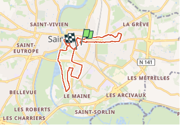
Trail Walking of 8.2 km to be discovered at New Aquitaine, Charente-Maritime, Saintes. This trail is proposed by Claudinette17.
Positioning
Country:
France
Region :
New Aquitaine
Department/Province :
Charente-Maritime
Municipality :
Saintes
Location:
Unknown
Start:(Dec)
Start:(UTM)
684886 ; 5068400 (30T) N.
Comments