


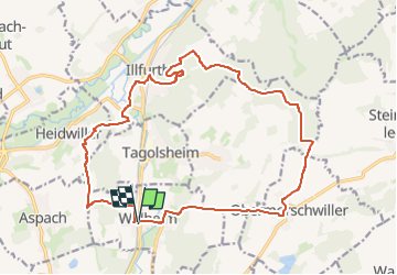
Walheim - Illfurth - Obermorschwiller .

Alain28/01
User

Length
19.1 km

Max alt
402 m

Uphill gradient
422 m
Km-Effort
25 km

Min alt
257 m

Downhill gradient
424 m
Boucle
Yes
Creation date :
2025-01-19 14:02:54.299
Updated on :
2025-01-19 14:05:04.684
5h36
Difficulty : Medium

FREE GPS app for hiking
 SityTrail
IGN / Geographical institutes
SityTrail Plus
The world is yours!
About
Trail Walking of 19.1 km to be discovered at Grand Est, Haut-Rhin, Walheim. This trail is proposed by Alain28/01.
Positioning
Country:
France
Region :
Grand Est
Department/Province :
Haut-Rhin
Municipality :
Walheim
Location:
Unknown
Start:(Dec)
Start:(UTM)
369619 ; 5277926 (32T) N.
Comments