


BRANCEILLES 2025

Gpoujade
User
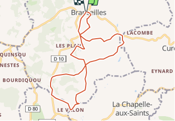

Length
10 km

Max alt
206 m

Uphill gradient
228 m
Km-Effort
13.1 km

Min alt
128 m

Downhill gradient
226 m
Boucle
Yes
Creation date :
2025-01-20 10:04:44.041
Updated on :
2025-01-20 10:05:30.743
2h58
Difficulty : Difficult

FREE GPS app for hiking
 SityTrail
IGN / Geographical institutes
SityTrail Plus
The world is yours!
About
Trail Walking of 10 km to be discovered at New Aquitaine, Corrèze, Branceilles. This trail is proposed by Gpoujade.
Positioning
Country:
France
Region :
New Aquitaine
Department/Province :
Corrèze
Municipality :
Branceilles
Location:
Unknown
Start:(Dec)
Start:(UTM)
398266 ; 4985017 (31T) N.
Comments