


bois st pierre

francejpp
User

Length
11.1 km

Max alt
145 m

Uphill gradient
114 m
Km-Effort
12.6 km

Min alt
108 m

Downhill gradient
117 m
Boucle
No
Creation date :
2025-01-21 13:03:48.498
Updated on :
2025-01-21 15:32:53.331
2h28
Difficulty : Easy

FREE GPS app for hiking
 SityTrail
IGN / Geographical institutes
SityTrail Plus
The world is yours!
About
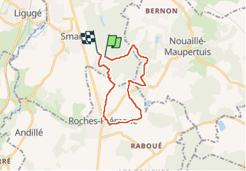
Trail Walking of 11.1 km to be discovered at New Aquitaine, Vienne, Smarves. This trail is proposed by francejpp.
Positioning
Country:
France
Region :
New Aquitaine
Department/Province :
Vienne
Municipality :
Smarves
Location:
Unknown
Start:(Dec)
Start:(UTM)
298330 ; 5153511 (31T) N.
Comments