


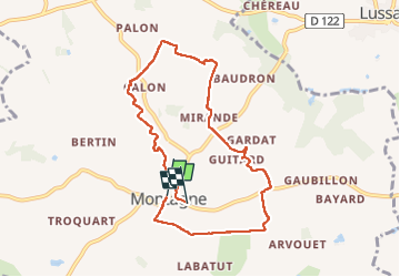
Monragne st Emilion

Gbreuilh
User

Length
8.5 km

Max alt
97 m

Uphill gradient
105 m
Km-Effort
9.9 km

Min alt
45 m

Downhill gradient
104 m
Boucle
No
Creation date :
2025-01-22 08:34:14.235
Updated on :
2025-01-22 10:51:36.645
2h17
Difficulty : Medium

FREE GPS app for hiking
 SityTrail
IGN / Geographical institutes
SityTrail Plus
The world is yours!
About
Trail Walking of 8.5 km to be discovered at New Aquitaine, Gironde, Montagne. This trail is proposed by Gbreuilh.
Positioning
Country:
France
Region :
New Aquitaine
Department/Province :
Gironde
Municipality :
Montagne
Location:
Unknown
Start:(Dec)
Start:(UTM)
726477 ; 4979242 (30T) N.
Comments