


COURCHONS DOLMEN TERRES BLANCHES CASTELLANE

clintest
User
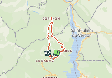

Length
10.6 km

Max alt
1410 m

Uphill gradient
386 m
Km-Effort
15.8 km

Min alt
1044 m

Downhill gradient
394 m
Boucle
Yes
Creation date :
2025-01-22 15:38:12.578
Updated on :
2025-01-22 15:38:47.183
3h35
Difficulty : Easy

FREE GPS app for hiking
 SityTrail
IGN / Geographical institutes
SityTrail Plus
The world is yours!
About
Trail On foot of 10.6 km to be discovered at Provence-Alpes-Côte d'Azur, Alpes-de-Haute-Provence, Castellane. This trail is proposed by clintest.
Positioning
Country:
France
Region :
Provence-Alpes-Côte d'Azur
Department/Province :
Alpes-de-Haute-Provence
Municipality :
Castellane
Location:
Unknown
Start:(Dec)
Start:(UTM)
299982 ; 4862980 (32T) N.
Comments