


St Jean d,Arves - L,Ouillon

laurentnecca
User
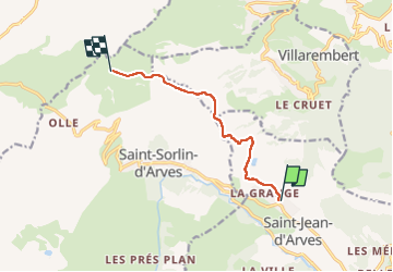

Length
7.3 km

Max alt
2370 m

Uphill gradient
864 m
Km-Effort
16.1 km

Min alt
1554 m

Downhill gradient
51 m
Boucle
No
Creation date :
2025-01-25 08:46:56.635
Updated on :
2025-01-25 12:56:11.571
2h44
Difficulty : Medium

FREE GPS app for hiking
 SityTrail
IGN / Geographical institutes
SityTrail Plus
The world is yours!
About
Trail Touring skiing of 7.3 km to be discovered at Auvergne-Rhône-Alpes, Savoy, Saint-Jean-d'Arves. This trail is proposed by laurentnecca.
Positioning
Country:
France
Region :
Auvergne-Rhône-Alpes
Department/Province :
Savoy
Municipality :
Saint-Jean-d'Arves
Location:
Unknown
Start:(Dec)
Start:(UTM)
285437 ; 5010231 (32T) N.
Comments