


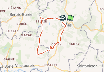
Celles La Tournevalade

audier
User


3h25
Difficulty : Easy

FREE GPS app for hiking
 SityTrail
IGN / Geographical institutes
SityTrail Plus
The world is yours!
About
Trail On foot of 11.9 km to be discovered at New Aquitaine, Dordogne, Celles. This trail is proposed by audier.
Description
Parcours par de petites routes,de chemins à travers les cultures.
Point de vue sur église de Bertric- Burée à Belair. Le village, l'église ,le château et l'étang de Celles.
Information:
Le chemin à droite La Barrière du Cluzeau, est défriché que sur une longueur,rentré dans le bois en restant sur la gauche et rattraper le champ au-dessus .Suivre la lisière sur la droite pour retrouver le chemin et partir sur la gauche.
Bonne randonnée.
Positioning
Comments