


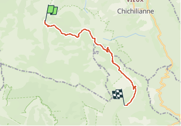
Chamaillouux Combo raquette

taguette
User

Length
11.1 km

Max alt
1946 m

Uphill gradient
356 m
Km-Effort
16.6 km

Min alt
1376 m

Downhill gradient
590 m
Boucle
No
Creation date :
2025-01-25 07:54:56.156
Updated on :
2025-01-26 16:52:15.652
5h39
Difficulty : Difficult

FREE GPS app for hiking
 SityTrail
IGN / Geographical institutes
SityTrail Plus
The world is yours!
About
Trail Walking of 11.1 km to be discovered at Auvergne-Rhône-Alpes, Isère, Chichilianne. This trail is proposed by taguette.
Positioning
Country:
France
Region :
Auvergne-Rhône-Alpes
Department/Province :
Isère
Municipality :
Chichilianne
Location:
Unknown
Start:(Dec)
Start:(UTM)
698657 ; 4964544 (31T) N.
Comments