


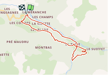
Le Cerney - Le Planey - St Pierre d'Extravache

Mariolebeno
User


3h11
Difficulty : Difficult

FREE GPS app for hiking
 SityTrail
IGN / Geographical institutes
SityTrail Plus
The world is yours!
About
Trail Walking of 9.7 km to be discovered at Auvergne-Rhône-Alpes, Savoy, Val-Cenis. This trail is proposed by Mariolebeno.
Description
Accès par la navette gratuite au départ de Bramans, la route est interdite à tout véhicule.
La partie en forêt qui emprunte la GRP tour de la Haute Maurienne, nécessite un peu d'attention, notamment pour la traversée du 1er torrent dans la forêt de Montbas.
une corde est présente pour sécuriser un petit passage mais elle est souvent prise par la neige l'hiver. En cas de neige gelée, il faut alors être vraiment sûr de soi.
La chapelle de St Pierre d'Extravache vaut le détour
Positioning
Comments