


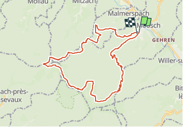
SityTrail - 3655666 - boucle-de-moosch-au-bellacker-x-moosch

gerard70
User

Length
19.7 km

Max alt
1151 m

Uphill gradient
939 m
Km-Effort
32 km

Min alt
403 m

Downhill gradient
930 m
Boucle
Yes
Creation date :
2025-01-27 12:39:32.24
Updated on :
2025-01-27 12:41:27.963
7h19
Difficulty : Difficult

FREE GPS app for hiking
 SityTrail
IGN / Geographical institutes
SityTrail Plus
The world is yours!
About
Trail On foot of 19.7 km to be discovered at Grand Est, Haut-Rhin, Moosch. This trail is proposed by gerard70.
Positioning
Country:
France
Region :
Grand Est
Department/Province :
Haut-Rhin
Municipality :
Moosch
Location:
Unknown
Start:(Dec)
Start:(UTM)
353574 ; 5302180 (32T) N.
Comments