


sickert

gerard70
User
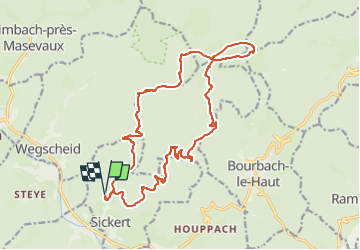

Length
19.8 km

Max alt
1162 m

Uphill gradient
1000 m
Km-Effort
33 km

Min alt
484 m

Downhill gradient
1002 m
Boucle
Yes
Creation date :
2025-01-28 15:02:57.268
Updated on :
2025-01-28 15:15:51.534
7h31
Difficulty : Difficult

FREE GPS app for hiking
 SityTrail
IGN / Geographical institutes
SityTrail Plus
The world is yours!
About
Trail On foot of 19.8 km to be discovered at Grand Est, Haut-Rhin, Sickert. This trail is proposed by gerard70.
Positioning
Country:
France
Region :
Grand Est
Department/Province :
Haut-Rhin
Municipality :
Sickert
Location:
Unknown
Start:(Dec)
Start:(UTM)
348517 ; 5295113 (32T) N.
Comments