


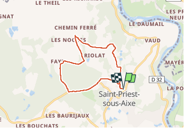
autour de st priest ss aixe

coeurdom
User

Length
6.5 km

Max alt
329 m

Uphill gradient
107 m
Km-Effort
7.9 km

Min alt
257 m

Downhill gradient
108 m
Boucle
Yes
Creation date :
2025-01-30 08:53:00.199
Updated on :
2025-01-30 10:25:58.949
1h27
Difficulty : Medium

FREE GPS app for hiking
 SityTrail
IGN / Geographical institutes
SityTrail Plus
The world is yours!
About
Trail Walking of 6.5 km to be discovered at New Aquitaine, Haute-Vienne, Saint-Priest-sous-Aixe. This trail is proposed by coeurdom.
Description
lancer le circuit et suivre le guidage
Positioning
Country:
France
Region :
New Aquitaine
Department/Province :
Haute-Vienne
Municipality :
Saint-Priest-sous-Aixe
Location:
Unknown
Start:(Dec)
Start:(UTM)
352452 ; 5075653 (31T) N.
Comments