


SAINT-CYPRIEN 66 - front de mer - les CAPELLANS

jeff66
User


2h11
Difficulty : Easy

FREE GPS app for hiking
 SityTrail
IGN / Geographical institutes
SityTrail Plus
The world is yours!
About
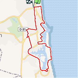
Trail Walking of 9.9 km to be discovered at Occitania, Pyrénées-Orientales, Saint-Cyprien. This trail is proposed by jeff66.
Description
SAINT-CYPRIEN 66 - front de mer - ports de pêche et plaisance - capitainerie - zone technique du port - pont mobile - les capellans - plage - Acapulco beach bar - résidence la Lagune - la cortaderia - marinas du ponant - hameau du rivage II - lot le sillage - parcours de santé - mas des CAPELLANS - résidence Marina village, les quais de l'amirauté - centre commercial des capellans - avenue Arnaud Lanoux - zone artisanale - mas de les Hortes - centre équestre - rue brantome - rapateil - résidence le clos de St Cyprien - rue du docteur Shweitzer - résidences le Calypso , de la mer, les jardins de Neptune, les lauriers roses -
Photos


Positioning
Comments
Découverte de Saint Cyprien, merci !