


Albane - Pointe des Chaudanes

laurentnecca
User
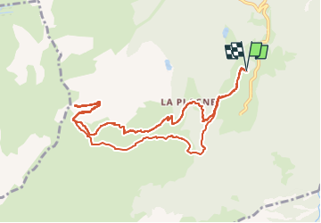

Length
11 km

Max alt
2484 m

Uphill gradient
799 m
Km-Effort
22 km

Min alt
1677 m

Downhill gradient
798 m
Boucle
Yes
Creation date :
2025-02-01 09:00:49.907
Updated on :
2025-02-01 13:31:16.523
2h57
Difficulty : Medium

FREE GPS app for hiking
 SityTrail
IGN / Geographical institutes
SityTrail Plus
The world is yours!
About
Trail Touring skiing of 11 km to be discovered at Auvergne-Rhône-Alpes, Savoy, Montricher-Albanne. This trail is proposed by laurentnecca.
Positioning
Country:
France
Region :
Auvergne-Rhône-Alpes
Department/Province :
Savoy
Municipality :
Montricher-Albanne
Location:
Albanne
Start:(Dec)
Start:(UTM)
297372 ; 5009572 (32T) N.
Comments