


geschouse

danif
User
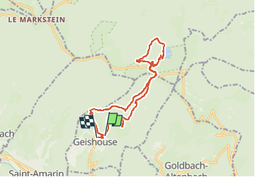

Length
14.9 km

Max alt
1228 m

Uphill gradient
713 m
Km-Effort
25 km

Min alt
738 m

Downhill gradient
749 m
Boucle
No
Creation date :
2025-02-06 08:19:50.036
Updated on :
2025-02-06 15:09:51.193
6h48
Difficulty : Very difficult

FREE GPS app for hiking
 SityTrail
IGN / Geographical institutes
SityTrail Plus
The world is yours!
About
Trail Walking of 14.9 km to be discovered at Grand Est, Haut-Rhin, Geishouse. This trail is proposed by danif.
Positioning
Country:
France
Region :
Grand Est
Department/Province :
Haut-Rhin
Municipality :
Geishouse
Location:
Unknown
Start:(Dec)
Start:(UTM)
355368 ; 5305397 (32T) N.
Comments