


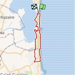
CANET-EN-ROUSSILLON 66 - entre mer, plage, dunes et étang - SAINT-CYPRIEN-PLAGE

jeff66
User


2h14
Difficulty : Medium

FREE GPS app for hiking
 SityTrail
IGN / Geographical institutes
SityTrail Plus
The world is yours!
About
Trail Walking of 12.5 km to be discovered at Occitania, Pyrénées-Orientales, Canet-en-Roussillon. This trail is proposed by jeff66.
Description
CANET-EN-ROUSSILLON 66 - la plage - passage à gué sur le Réart - promenade dans les dunes - bord de mer - SAINT-CYPRIEN-PLAGE - promenade entre plage et résidences - pétanque maritime - hôtel Mar I Sol - D81A - résidences archipel, les nouvelles mirandas - rue René Bazin - plage de l'art - Les Caselas - rue madame de sevigné - rue Auguste Barbier - rue Edmond michelet - résidence vivre le 3ieme âge - rue Jouy d'Arnaud - étang de CANET ET DE SAINT-NAZAIRE - la Bassa vella - poste d'observation ornithologique - le grau de l'étang de CANET - baraques pêcheurs - la Muntinya Alta
Photos


Positioning
Comments