


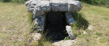
Saint-Cernin-Chasteaux- les dolmens

houbart
User
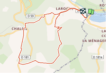

Length
5.8 km

Max alt
274 m

Uphill gradient
184 m
Km-Effort
8.3 km

Min alt
121 m

Downhill gradient
184 m
Boucle
Yes
Creation date :
2019-03-28 15:47:31.219
Updated on :
2019-03-28 15:47:31.289
1h45
Difficulty : Easy

FREE GPS app for hiking
 SityTrail
IGN / Geographical institutes
SityTrail Plus
The world is yours!
About
Trail Walking of 5.8 km to be discovered at New Aquitaine, Corrèze, Chasteaux. This trail is proposed by houbart.
Description
Sur le Causse corrézien, découverte de dolmens et vue sur le cirque de la Doux.
Départ sur la D19, près de la digue du lac du Causse.
Photos


Positioning
Country:
France
Region :
New Aquitaine
Department/Province :
Corrèze
Municipality :
Chasteaux
Location:
Unknown
Start:(Dec)
Start:(UTM)
376519 ; 4994394 (31T) N.
Comments
super à faire avec des chiens. très peu de route